Title:
Reconnaissance survey on geotechnical damage caused by February 6, 2023, Kahramanmaraş Earthquake, Türkiye
Authour:
Seda SENDIR TORISU1, Tetsuo TOBITA2, Takashi KIYOTA3, Ozer CINICIOGLU4, Gokce TONUK5, Nikolay MILEV6, Juan BRIONES7, and Othron BRIONES7
1 Member of JSCE, Civil Engineer, Nuclear Facilities Division, Obayashi Corporation
2 Member of JSCE, Professor, Department of Civil, Environmental and Systems Engineering, Kansai University
3 Member of JSCE, Professor, Institute of Industrial Science, University of Tokyo
4 Professor, Department of Civil Engineering, Bogazici University
5 Assistant Professor, Department of Civil Engineering, MEF University
6 Chief Assistant Professor, Faculty of Transportation Eng., Geotechnics, University of Architecture, Civil Engineering and Geodesy
7 Engineer, Geofizika EIG Ltd.
Key Facts
- Hazard Type: Earthquake
- Date of the disaster: February 6th, 2023
- Location of the survey: Islahiye, Tepehan, Iskenderun, Antakya, Golbasi, Kahramanmaras
- Date of the field survey: March 29th – April 2nd 2023
- Survey tools: Drone, Digital camera, GPS, Laser rangefinder, Microtremor
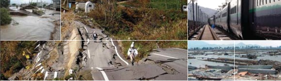
Key findings: landslides, liquefaction, inundation, settlement, embankment failure
Key Words: Kahramanmaras Earthquake, geotechnical damage, liquefaction, lateral spread, landslide, inundation, settlement
Paper: PDF 2,667KB